

What is a Watershed?
Every drop of rain that lands on earth goes somewhere. Some soaks into the roots of the nearest thirsty plant. Excess moisture is taken up into the atmosphere as evaporation. But not all rain lands on soft earth. Rooftops, sidewalks, roads, and parking lots are constructed to allow water to roll right off of them.
That’s actually the definition of a watershed. Any time water moves, it goes downhill. If we followed a set of raindrops after they land, their journey might look a lot like the route you’d take for a trip to Fayetteville. If you live outside town, you might start with a narrow driveway (trickle) that takes you to a dirt county road (rivulet), then on to a paved state highway (creek), and eventually to Hwy 412 heading to the city (river). You might even end up on Interstate 49 (Mississippi River!).
Raindrops that accumulate in a puddle on a parking lot in Berryville move down the lot to a gutter that drains through a culvert into a small urban stream, like Mill Creek. Mill Creek joins with several larger streams until it reaches Osage Creek. From there, the water flows until it joins the Kings River west of Berryville.
The Journey from Headwaters to the Gulf
The Kings River begins far south in the Boston Mountains of Madison County and flows northward across south Carroll County looking like a beautiful green-blue ribbon. As it winds north, feeder creeks continuously add volume before the river mingles with the waters of Table Rock Lake.
Before Table Rock and the other large reservoir dams were built, the Kings River flowed into the mighty White River. Water released through the dams returns to the White River, joins the Arkansas River, flows into the Mississippi, and ultimately empties into the Gulf of Mexico. Rain falling in Carroll County may truly end up in the ocean!
Everyone lives in not just one watershed, but in a series of connected, telescoping watersheds. The things we do on our land have a cumulative effect on the health of our shared water resources.
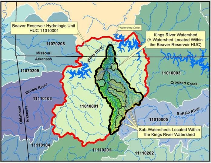
Northwest Arkansas major drainage basins
Regional river basin connectivity