
Water Quality Monitoring Program
Local residents’ concerns over the state of water quality in the Kings River and its tributaries led to the creation of the KRWP water testing program in 2005. The goal of this program is to collect data based on solid scientific methods which establish baseline measures of water quality in the watershed. This ongoing study serves as a reference point to monitor future changes in local streams.
Member dues and donations provide funding for this program. Tyson Foods, a major employer and integral part of the agricultural industry in the watershed, generously donated $1,850 in November 2006 to support KRWP’s water quality monitoring program and renewed their support in subsequent years.
A grant from the Arkansas Game and Fish Commission’s Stream Team program provided funding for our original water monitoring test kit. Many volunteers have been trained over the years to follow strict protocols described in our Quality Assurance Project Plan (QAPP), adopted in conjunction with the Arkansas Water Resources Center (AWRC) at the University of Arkansas, the Upper White River Basin Foundation, and the EPA.
Testing Parameters & Multi-Probe Meter
Quality measures were further strengthened with the addition of a YSI multi-probe field meter. This device tests 5 different parameters for water quality in real time. KRWP’s program works toward test results comparing as closely as possible to matching samples sent to the AWRC Lab.
Physical and Chemical Tests Conducted:
- Stream Depth & Flow Rate
- Air and Water Temperature
- Dissolved Oxygen (DO)
- pH Levels
- Total Dissolved Solids (TDS)
- Hardness
- Alkalinity
- Turbidity (Water Clarity)
- Nitrates
- Phosphates
Monitoring Sites Across the Watershed
In the early days of the program, samples were collected from 12 locations across the watershed, from the headwaters to Table Rock Lake, including Piney Creek, Dry Fork Creek, Osage Creek, and Keel’s Creek. Data from this period led us to select five primary long-term monitoring sites:
- Site #1: Upper Osage Creek (above Berryville’s impact)
- Site #2: Lower Osage Creek (below Berryville’s wastewater treatment plant)
- Site #3: Kings River above Osage Confluence (snapshot of the river prior to Osage contribution)
- Site #4: Upper Kings River near Hwy 74 bridge (above Kingston)
- Site #5: Lower Kings River at Stoney Point Access (below USGS Grandview gauging station)
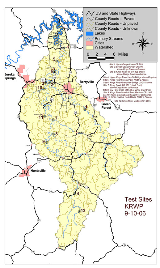
Primary and tributary water sampling stations
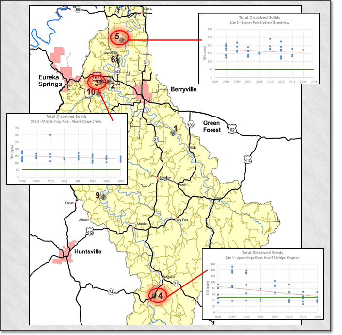
Total Dissolved Solids (TDS) comparative monitoring sites